Thank a Streetcar: The Forgotten History Behind Minneapolis’ Classic Craftsman Duplexes
 Have you ever wondered why all of the classic Craftsman-era duplexes in Minneapolis seem to be in the same neighborhoods?
If you own a duplex in South Minneapolis, there’s a good chance you can thank a streetcar for it.
There’s a very good chance the duplex with woodwork and built-ins you’re currently renting, or own was built within walking distance of a streetcar line.
It started when Thomas Lowry (the one the neighborhood is named after) assumed control of the Minneapolis street railway companies in 1886. He was skeptical of electrification at first. The Minneapolis City Council forced his hand. In 1889, an experimental electric line entered service on Fourth Avenue South, and once it proved successful, Lowry’s company was required to purchase it.
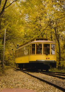
In 1891, Lowry merged the Minneapolis and St. Paul Street Rail Companies into the Twin City Rapid Transit Company (TCRT), converted all remaining horse car lines to electric, and started building new lines at a steady rate. By the early 1920’s, TCRT operated more than 900 streetcars, had 523 miles of track across the Twin Cities metro, and carried over 200 million passengers a year.
Lowry’s streetcar lines radiated outward from the city center, opening up nearby farmland for residential development. The TCRT wasn’t just a transit company. It was, functionally, a real estate development engine. Extend a line into undeveloped land, and suddenly that land is worth something. Developers platted subdivisions. Builders followed. Commercial nodes sprouted at key trolley stops like Lake Street and Hennepin Avenue and adjacent neighborhoods were developed with support from TCRT.
Streetcar development and real estate development acted hand-in-hand, and nearly all of today’s prominent commercial corridors were established first as streetcar corridors.
Minneapolis’ Seven Streetcar Sectors
Between World War I and the early 1950s, streetcar traffic along major lines to and from downtown jobs, shopping, and entertainment shaped seven distinct residential sectors: Minnehaha; South Central (Nicollet, Chicago, Bloomington); Southwest (Hennepin, Lake District, West Lake Street); Near North (Glenwood, Plymouth); North (Washington, Emerson, Penn, Broadway); Northeast (2nd Street, Central, Johnson); and Southeast (Como, Washington, University).
Each corridor had its own character. But they shared a common development pattern: denser housing closer to the lines, with single-family homes fanning out from there. The blocks immediately adjacent to streetcar routes are where you find the heaviest concentration of duplexes built in the early 20th century because the population density was necessary to make the ridership numbers work.
- The Wedge / Lowry Hill East – The Lowry Hill East Residential Historic District emerged in the late 1800s and early 1900s directly because of streetcar expansion. In the 1880s, streetcar service expanded down Lyndale Avenue from downtown, leading to significant urban development outside of the central business district. The interior of the neighborhood filled with large early 20th century homes and multi-unit apartment buildings, while the border streets lined with small businesses.
- Whittier – Whittier filled along Thomas Lowry’s new Nicollet Avenue and 4th Avenue streetcar routes as the increasingly residential character of south Minneapolis expanded in the early 20th century. The density of duplexes and small apartment buildings along those corridors reflects exactly what builders were doing: putting housing within easy walking distance of the line.
- Nicollet and Lake Street – Between 1920 and 1950, the intersection of Nicollet Avenue and Lake Street reached its peak as a commercial shopping district at the intersection of two heavily used streetcar lines. The residential blocks surrounding that corridor were built up in tandem, as workers needed places to live near the transit they depended on. The Nicollet line operated from 1879 through the streetcar era and provided constant ridership service to Loring Park, Stevens Square, Whittier, Lyndale, Kingfield, Tangletown, and Windom neighborhoods. Several business districts popped up along Nicollet at major crossroads such as 26th, Lake, 38th, 43rd, 46th, 48th, 54th, and 58th streets. Every one of those intersections anchored a cluster of multifamily housing nearby.
- South Minneapolis – Between 1900 and 1920, the population of Minneapolis expanded rapidly, and between 1921 and 1926, wards bounded by 54th Street showed the greatest population growth of any part of the city, with a greater home-building record than all other wards combined. Access to the streetcar line was still considered an amenity in the early 1920s even as automobile ownership began to rise.
- Southwest: Bryant, Xerxes, France – Beginning in 1890, the Bryant-Penn line served the East Harriet, Lynnhurst, Kenny, and Armatage neighborhoods, first connecting downtown Minneapolis to 38th & Bryant before expanding further south. With the extension of the Bryant-Penn line came the development of many brownstone apartment buildings alongside Bryant Avenue and single-family homes along surrounding blocks throughout the twentieth century. The small business district at 50th & Xerxes exists because it was once a heavily traveled streetcar junction.
- Longfellow – The Longfellow community was also largely developed between 1906 and the 1920s. The Craftsman bungalows and duplexes the neighborhood is known for were built by people who needed to be able to get downtown without a car.
History Repeats Itself
Minneapolis’ 2040 plan is somewhat reminiscent of the streetcar-era. In the early 1900’s the city had no problem including duplexes and small apartment buildings in residential neighborhoods.
Then, as now, a duplex close to public transportation like a streetcar line or light rail is a desirable location. Builders of both eras bet on growth and put up buildings. One only needs to drive along any of the light rail corridors to see modern proof of the theory.
Unfortunately, the streetcar system’s downturn began shortly after its peak. Mass production of automobiles in the 1920s made them more affordable for consumers, which cut into ridership. In fact, ridership fell 48 percent from 1920 to 1932.
The last streetcar made its final run in Minneapolis 72 years ago on June 19, 1954. But it sure left us with some great duplexes.